
San Miguel Island topographic map
Interactive map
Click on the map to display elevation.
About this map
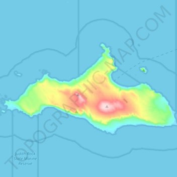
Name: San Miguel Island topographic map, elevation, terrain.
Average elevation: 21 m
Minimum elevation: 0 m
Maximum elevation: 253 m
Other topographic maps
Click on a map to view its topography, its elevation and its terrain.
Santa Barbara
United States > California > Santa Barbara County
Santa Barbara, Santa Barbara County, California, United States
Average elevation: 119 m
Naples
United States > California > Santa Barbara County
Naples, Santa Barbara County, California, United States
Average elevation: 25 m
Haskell's Beach
United States > California > Santa Barbara County > Goleta
Haskell's Beach, Goleta, Santa Barbara County, California, United States
Average elevation: 15 m
San Pedro Point
United States > California > Santa Barbara County
San Pedro Point, Santa Barbara County, California, United States
Average elevation: 12 m
Channel Islands
United States > California > Santa Barbara County
Channel Islands, Santa Barbara County, CAL Fire Southern Region, California, 90704, United States
Average elevation: 4 m
Sutil Island
United States > California > Santa Barbara County
Sutil Island, Santa Barbara County, California, United States
Average elevation: 14 m
Montecito
United States > California > Santa Barbara County
Montecito, Santa Barbara County, CAL Fire Southern Region, California, 93108, United States
Average elevation: 216 m
Goleta
United States > California > Santa Barbara County
Goleta, Santa Barbara County, California, 93117, United States
Average elevation: 57 m
Buellton
United States > California > Santa Barbara County
Buellton, Santa Barbara County, CAL Fire Southern Region, California, 93427, United States
Average elevation: 127 m
Las Positas Meadows
United States > California > Santa Barbara County > Santa Barbara
Las Positas Meadows, Santa Barbara, Santa Barbara County, CAL Fire Southern Region, California, 93105, United States
Average elevation: 66 m
Orcutt
United States > California > Santa Barbara County
Orcutt, Santa Barbara County, CAL Fire Southern Region, California, 93455, United States
Average elevation: 155 m
Solvang
United States > California > Santa Barbara County
Solvang, Santa Barbara County, California, United States
Average elevation: 194 m
Isla Vista
United States > California > Santa Barbara County
Isla Vista, Santa Barbara County, California, 93106, United States
Average elevation: 6 m
Santa Maria
United States > California > Santa Barbara County
Santa Maria, Santa Barbara County, CAL Fire Southern Region, California, United States
Average elevation: 86 m
Lompoc
United States > California > Santa Barbara County > Lompoc
Lompoc, Santa Barbara County, California, 93436, United States
Average elevation: 57 m
Santa Maria
United States > California > Santa Barbara County > Santa Maria
Santa Maria, Santa Barbara County, California, 93454, United States
Average elevation: 185 m
Toro Canyon
United States > California > Santa Barbara County > Toro Canyon
Toro Canyon, Santa Barbara County, California, 93013:93108, United States
Average elevation: 83 m
Santa Cruz Island
United States > California > Santa Barbara County
Santa Cruz Island, Santa Barbara County, California, United States
Average elevation: 37 m
Santa Rosa Island
United States > California > Santa Barbara County
Santa Rosa Island, Santa Barbara County, CAL Fire Southern Region, California, United States
Average elevation: 51 m
Cathedral Peak
United States > California > Santa Barbara County
Cathedral Peak, Santa Barbara County, CAL Fire Southern Region, California, 93105, United States
Average elevation: 774 m
Carpinteria
United States > California > Santa Barbara County
Carpinteria, Santa Barbara County, California, 93013, United States
Average elevation: 10 m
Santa Ynez
United States > California > Santa Barbara County
Santa Ynez, Santa Barbara County, California, 93460, United States
Average elevation: 195 m
Los Olivos
United States > California > Santa Barbara County
Los Olivos, Santa Barbara County, California, 93441, United States
Average elevation: 277 m