
Make a donation
Mozarlândia topographic map
Click on the map to display elevation.
Make a donation
Mozarlândia
The main rivers that bathe the municipality are the Rio Tesouras and Rio do Peixe, besides the streams (córregos) of Alagadinho, Alagado, São João, Fogueira, Barreirinho, do Gato, Lagoinha, do Buriti, do Manoel and Muquém. Because of the flat topography near the main rivers, there are places that have a rich formation in lakes: Landi, Lolito, Pedra, Correia, da Onça, da Mãe, Redondo, Cabaça and many others. The mountains that stand out are Constantino, Pimenta, Pouso Alto, Jiripoca, Tombador and Bananal and the hills of São João and Engano.
Make a donation
About this map
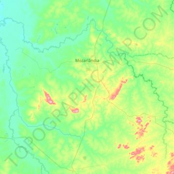
Name: Mozarlândia topographic map, elevation, terrain.
Average elevation: 300 m
Minimum elevation: 235 m
Maximum elevation: 557 m
Make a donation
Other topographic maps
Click on a map to view its topography, its elevation and its terrain.
Make a donation
Rosa
Brazil > Goiás > Região Integrada de Desenvolvimento do Distrito Federal e Entorno > Pirenópolis
Average elevation: 780 m
Bom Jesus
Brazil > Goiás > Região Integrada de Desenvolvimento do Distrito Federal e Entorno > Pirenópolis
Average elevation: 760 m
Make a donation
Rio Arraial Velho
Brazil > Goiás > Região Integrada de Desenvolvimento do Distrito Federal e Entorno > Água Fria de Goiás
Average elevation: 847 m
Paiol Velho
Brazil > Goiás > Região Integrada de Desenvolvimento do Distrito Federal e Entorno > Pirenópolis
Average elevation: 730 m