
Thank you for supporting this site ❤️
Make a donation
Make a donation
حراز topographic map
Click on the map to display elevation.
Thank you for supporting this site ❤️
Make a donation
Make a donation
About this map
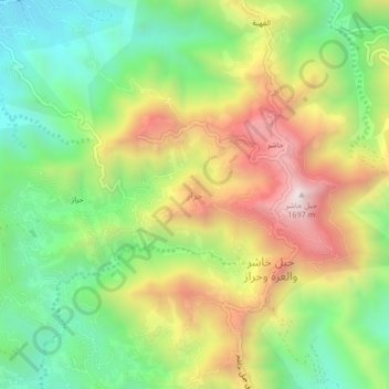
Name: حراز topographic map, elevation, terrain.
Location: حراز, Al ddayer, Jazan Province, 23501, Saudi Arabia (17.29370 43.14449 17.33370 43.18449)
Average elevation: 1,128 m
Minimum elevation: 709 m
Maximum elevation: 1,693 m
Thank you for supporting this site ❤️
Make a donation
Make a donation
Other topographic maps
Click on a map to view its topography, its elevation and its terrain.