
Thank you for supporting this site ❤️
Make a donation
Make a donation
Kotelnich topographic map
Click on the map to display elevation.
Thank you for supporting this site ❤️
Make a donation
Make a donation
About this map
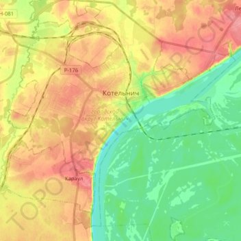
Name: Kotelnich topographic map, elevation, terrain.
Location: Kotelnich, Kirov Oblast, Volga Federal District, Russia (58.25473 48.26299 58.33695 48.41177)
Average elevation: 116 m
Minimum elevation: 79 m
Maximum elevation: 157 m
Thank you for supporting this site ❤️
Make a donation
Make a donation
Other topographic maps
Click on a map to view its topography, its elevation and its terrain.