
Thank you for supporting this site ❤️
Make a donation
Make a donation
Girardot topographic map
Click on the map to display elevation.
Thank you for supporting this site ❤️
Make a donation
Make a donation
Girardot
The municipality lies on a plain, framed by the foothills of the Cordillera Oriental, without notable topographic features, with some areas of difficult access in the mountainous area on the border with Nariño called Alonso Vera cordillera.
Thank you for supporting this site ❤️
Make a donation
Make a donation
About this map
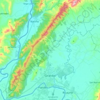
Name: Girardot topographic map, elevation, terrain.
Location: Girardot, Alto Magdalena, Cundinamarca, Colombia (4.26535 -74.89052 4.43424 -74.73911)
Average elevation: 358 m
Minimum elevation: 232 m
Maximum elevation: 935 m
Thank you for supporting this site ❤️
Make a donation
Make a donation
Other topographic maps
Click on a map to view its topography, its elevation and its terrain.