
Flanders topographic map
Interactive map
Click on the map to display elevation.
About this map
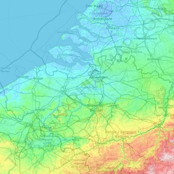
Name: Flanders topographic map, elevation, terrain.
Location: Flanders, Belgium (50.68738 2.54136 51.50511 5.91111)
Average elevation: 61 m
Minimum elevation: -7 m
Maximum elevation: 641 m
Other topographic maps
Click on a map to view its topography, its elevation and its terrain.
Anderlecht
Anderlecht, Brussels-Capital, 1070, Belgium
Average elevation: 51 m
Petit-Axhe
Belgium > Liège > Waremme > Waremme
Petit-Axhe, Waremme, Liège, Wallonia, 4300, Belgium
Average elevation: 125 m
Brussels
Belgium > Brussels-Capital > Brussels
Brussels, Brussels-Capital, Belgium
Average elevation: 54 m
Ottignies-Louvain-la-Neuve
Belgium > Wallonia > Ottignies-Louvain-la-Neuve
Ottignies-Louvain-la-Neuve, Nivelles, Walloon Brabant, Wallonia, Belgium
Average elevation: 103 m
Sambreville
Belgium > Wallonia > Sambreville
Sambreville, Namur, Wallonia, 5060, Belgium
Average elevation: 139 m
Oudsbergen
Belgium > Flanders > Oudsbergen
Oudsbergen, Maaseik, Limburg, Flanders, Belgium
Average elevation: 70 m
Le Train
Belgium > Wallonia > Grez-Doiceau
Le Train, Grez-Doiceau, Nivelles, Walloon Brabant, Wallonia, 1390, Belgium
Average elevation: 63 m