
Make a donation
Avery County topographic map
Click on the map to display elevation.
Make a donation
Avery County
Avery County is extremely rural and mountainous with all of the county's terrain located within the Appalachian Mountains range; with a mean altitude of 3,510 feet or 1,070 metres it is the second-highest county east of the Mississippi behind nearby Haywood County. The highest point in the county is Grassy Ridge Bald, 6,165 feet (1,879 m) above sea level. Most of Grandfather Mountain, whose highest point is 5,946 feet (1,812 m) Calloway Peak on the tri-point bordering Watauga and Caldwell Counties, is within Avery County. At 5,526 feet or 1,684 metres, Beech Mountain (also shared with Watauga County) is the highest incorporated community east of the Mississippi River, while at 3,606 feet or 1,099 metres Newland is the highest county seat in the Eastern United States.
Make a donation
About this map
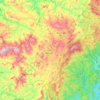
Name: Avery County topographic map, elevation, terrain.
Location: Avery County, North Carolina, United States (35.91151 -82.08110 36.28714 -81.73568)
Average elevation: 1,006 m
Minimum elevation: 339 m
Maximum elevation: 1,901 m
Make a donation
Other topographic maps
Click on a map to view its topography, its elevation and its terrain.
Appalachian Mountains
United States > North Carolina > Yancey County
The Appalachian Mountains (French: Appalaches), often called the Appalachians, are a system of mountains in eastern to northeastern North America. The Appalachians first formed roughly 480 million years ago during the Ordovician Period. They once reached elevations similar to those of the Alps and the Rocky…
Average elevation: 1,463 m
Make a donation
Kuwohi
United States > North Carolina > Swain County
At an elevation of 6,643 feet (2,025 m), it is the highest mountain in the Great Smoky Mountains National Park, the highest point in the state of Tennessee, and the highest point along the 2,192-mile (3,528 km) Appalachian Trail. It is also the third highest point in eastern mainland North America, after Mount…
Average elevation: 1,716 m
Make a donation
Make a donation
Highlands
United States > North Carolina > Macon County > Highlands
Highlands was founded in 1875 after its two founders, Samuel Truman Kelsey and Clinton Carter Hutchinson, drew lines from Chicago to Savannah and from New Orleans to New York City. They felt that the place where these lines met would eventually become a great trading center and commercial crossroads. Highlands…
Average elevation: 1,090 m
Make a donation
Make a donation
Make a donation
Ogden Park
United States > North Carolina > New Hanover County > Wilmington > Ogden
Average elevation: 13 m
Make a donation
Make a donation
Elk Knob
United States > North Carolina > Watauga County
Elk Knob is a mountain in the North Carolina High Country, north of the community of Meat Camp. Its elevation reaches 5,538 feet (1,688 m).
Average elevation: 1,362 m
Make a donation
Make a donation
Cataloochee Valley Viewpoint
United States > North Carolina > Haywood County > Cataloochee
Average elevation: 1,058 m
Make a donation
Make a donation
Kuwohi
United States > North Carolina > Swain County
At an elevation of 6,643 feet (2,025 m), it is the highest mountain in the Great Smoky Mountains National Park, the highest point in the state of Tennessee, and the highest point along the 2,192-mile (3,528 km) Appalachian Trail. It is also the third highest point in eastern mainland North America, after Mount…
Average elevation: 1,716 m
Ravensford
United States > North Carolina > Swain County > Yellowhill Community
Average elevation: 771 m
Make a donation
Make a donation
Make a donation
Make a donation
Mount Mitchell
United States > North Carolina > Yancey County
Mount Mitchell, known in Cherokee as Attakulla, is the highest peak of the Appalachian Mountains and the highest peak in mainland eastern North America. It is located near Burnsville in Yancey County, North Carolina in the Black Mountain subrange of the Appalachians about 19 miles (31 km) northeast of…
Average elevation: 1,743 m
Little Switzerland
United States > North Carolina > McDowell County
Little Switzerland is an unincorporated community in McDowell and Mitchell counties of North Carolina, United States. It is located along North Carolina Highway 226A (NC 226A) off the Blue Ridge Parkway, directly north of Marion and south of Spruce Pine. The elevation is 3,468 feet (1,057 m) above sea level.
Average elevation: 935 m
Buckeye Lake
United States > North Carolina > Watauga County > Beech Mountain
Average elevation: 1,160 m
Make a donation
Make a donation
Griffith Lakes
United States > North Carolina > Mecklenburg County > Charlotte
Average elevation: 244 m
Make a donation
Lake Raleigh
United States > North Carolina > Wake County > Raleigh > Isle Forest
Average elevation: 104 m
Make a donation
Make a donation
Make a donation
Make a donation
Make a donation
Make a donation