
Thank you for supporting this site ❤️
Make a donation
Make a donation
Clabecq topographic map
Click on the map to display elevation.
Thank you for supporting this site ❤️
Make a donation
Make a donation
About this map
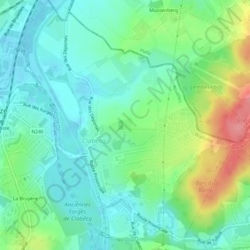
Name: Clabecq topographic map, elevation, terrain.
Location: Clabecq, Tubize, Nivelles, Brabant wallon, Wallonie, Belgique (50.67755 4.20841 50.70523 4.24654)
Average elevation: 58 m
Minimum elevation: 36 m
Maximum elevation: 111 m
Thank you for supporting this site ❤️
Make a donation
Make a donation
Other topographic maps
Click on a map to view its topography, its elevation and its terrain.