
Thank you for supporting this site ❤️
Make a donation
Make a donation
Forest Coal Pit topographic map
Click on the map to display elevation.
Thank you for supporting this site ❤️
Make a donation
Make a donation
About this map
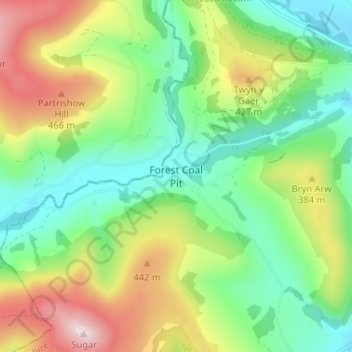
Name: Forest Coal Pit topographic map, elevation, terrain.
Location: Forest Coal Pit, Monmouthshire, Wales, NP7 7LN, United Kingdom (51.86069 -3.06095 51.90069 -3.02095)
Average elevation: 306 m
Minimum elevation: 149 m
Maximum elevation: 582 m
Thank you for supporting this site ❤️
Make a donation
Make a donation
Other topographic maps
Click on a map to view its topography, its elevation and its terrain.
Thank you for supporting this site ❤️
Make a donation
Make a donation
Thank you for supporting this site ❤️
Make a donation
Make a donation