
Thank you for supporting this site ❤️
Make a donation
Make a donation
Franconia Township topographic map
Click on the map to display elevation.
Thank you for supporting this site ❤️
Make a donation
Make a donation
About this map
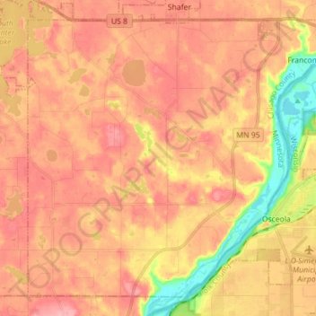
Name: Franconia Township topographic map, elevation, terrain.
Average elevation: 273 m
Minimum elevation: 205 m
Maximum elevation: 310 m
Thank you for supporting this site ❤️
Make a donation
Make a donation
Other topographic maps
Click on a map to view its topography, its elevation and its terrain.
Chain Lake
United States > Minnesota > Chisago County > North Branch > Harris
Average elevation: 281 m