
Lassen Peak topographic map
Interactive map
Click on the map to display elevation.
About this map
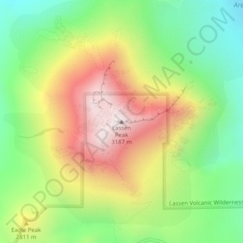
Name: Lassen Peak topographic map, elevation, terrain.
Location: Lassen Peak, Shasta County, California, United States (40.48808 -121.50497 40.48818 -121.50487)
Average elevation: 2,689 m
Minimum elevation: 2,311 m
Maximum elevation: 3,164 m
Lassen Peak, commonly referred to as Mount Lassen, is a lava dome volcano and the southernmost active volcano in the Cascade Range of the Western United States. Located in the Shasta Cascade region of Northern California, it is part of the Cascade Volcanic Arc, which stretches from southwestern British Columbia to northern California. Lassen Peak reaches an elevation of 10,457 ft (3,187 m), standing above the northern Sacramento Valley. It supports many flora and fauna among its diverse habitats, which are subject to frequent snowfall and reach high elevations.
Other topographic maps
Click on a map to view its topography, its elevation and its terrain.
Cassel
United States > California > Shasta County
Cassel, Shasta County, California, 96016, United States
Average elevation: 972 m
Seven Lakes Basin
United States > California > Shasta County
Seven Lakes Basin, Shasta County, California, United States
Average elevation: 1,964 m
Eskimo Hill
United States > California > Shasta County
Eskimo Hill, Shasta County, California, United States
Average elevation: 1,843 m
Viola
United States > California > Shasta County
Viola, Shasta County, California, United States
Average elevation: 1,371 m
Old Station
United States > California > Shasta County
Old Station, Shasta County, California, 96071, United States
Average elevation: 1,383 m
Turquoise Pool
United States > California > Shasta County
Turquoise Pool, Bumpass Hell Boardwalk, Shasta County, California, United States
Average elevation: 2,406 m
Lake Britton
United States > California > Shasta County
Lake Britton, Shasta County, California, United States
Average elevation: 939 m
Sherman
United States > California > Shasta County
Sherman, Shasta County, California, United States
Average elevation: 370 m
Redding
United States > California > Shasta County
Redding, Shasta County, California, United States
Average elevation: 240 m
Platina
United States > California > Shasta County
Platina, Shasta County, California, 96076, United States
Average elevation: 770 m
Burney
United States > California > Shasta County
Burney, Shasta County, California, 96013, United States
Average elevation: 989 m
Bella Vista
United States > California > Shasta County
Bella Vista, Shasta County, California, 96008, United States
Average elevation: 188 m
Redding
United States > California > Shasta County > Redding
Redding, Shasta County, California, 96049-6073, United States
Average elevation: 312 m
Shingletown
United States > California > Shasta County
Shingletown, Shasta County, California, United States
Average elevation: 920 m
Lakehead
United States > California > Shasta County
Lakehead, Shasta County, California, 96051, United States
Average elevation: 407 m
Montgomery Creek
United States > California > Shasta County
Montgomery Creek, Shasta County, California, United States
Average elevation: 742 m
McArthur
United States > California > Shasta County
McArthur, Shasta County, California, 96056, United States
Average elevation: 1,004 m
Shingletown
United States > California > Shasta County
Shingletown, Shasta County, California, 96088, United States
Average elevation: 920 m
Centerville
United States > California > Shasta County
Centerville, Shasta County, California, United States
Average elevation: 289 m
Shasta Lake
United States > California > Shasta County
Shasta Lake, Shasta County, California, United States
Average elevation: 265 m
Shasta Lake
United States > California > Shasta County
Shasta Lake, Shasta County, California, United States
Average elevation: 281 m
Palo Cedro
United States > California > Shasta County > Palo Cedro
Palo Cedro, Shasta County, California, 96073, United States
Average elevation: 157 m
Ward Butte
United States > California > Shasta County
Ward Butte, Shasta County, California, United States
Average elevation: 1,390 m
Anderson
United States > California > Shasta County
Anderson, Shasta County, California, 96007, United States
Average elevation: 148 m
Cottonwood
United States > California > Shasta County
Cottonwood, Shasta County, California, United States
Average elevation: 140 m
Anderson
United States > California > Shasta County
Anderson, Shasta County, CAL Fire Northern Region, California, 96007, United States
Average elevation: 151 m
Fall River Mills
United States > California > Shasta County
Fall River Mills, Shasta County, California, 96028, United States
Average elevation: 1,022 m
Monarch Mountain
United States > California > Shasta County
Monarch Mountain, Shasta County, California, 96095, United States
Average elevation: 566 m