
Frénois topographic map
Interactive map
Click on the map to display elevation.
About this map
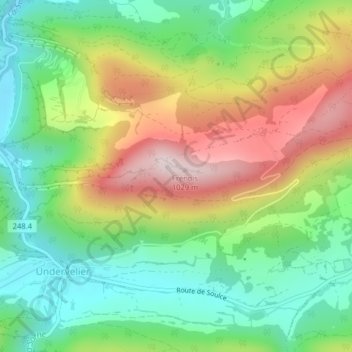
Name: Frénois topographic map, elevation, terrain.
Location: Frénois, Haute-Sorne, District de Delémont, Jura, 2863, Suisse (47.31051 7.23689 47.31061 7.23699)
Average elevation: 711 m
Minimum elevation: 513 m
Maximum elevation: 1,013 m
Other topographic maps
Click on a map to view its topography, its elevation and its terrain.
Jolimont
Suisse > Jura > Haute-Sorne
Jolimont, Haute-Sorne, District de Delémont, Jura, 2863, Suisse
Average elevation: 799 m
Undervelier
Suisse > Jura > Haute-Sorne
Undervelier, Haute-Sorne, District de Delémont, Jura, 2863, Suisse
Average elevation: 784 m