
Thank you for supporting this site ❤️
Make a donation
Make a donation
Rhineland-Palatinate topographic map
Click on the map to display elevation.
Thank you for supporting this site ❤️
Make a donation
Make a donation
About this map
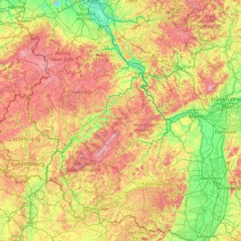
Name: Rhineland-Palatinate topographic map, elevation, terrain.
Location: Rhineland-Palatinate, Germany (48.96608 6.11225 50.94230 8.50831)
Average elevation: 296 m
Minimum elevation: 37 m
Maximum elevation: 882 m
Thank you for supporting this site ❤️
Make a donation
Make a donation
Other topographic maps
Click on a map to view its topography, its elevation and its terrain.