
Thank you for supporting this site ❤️
Make a donation
Make a donation
Cittanova topographic map
Click on the map to display elevation.
Thank you for supporting this site ❤️
Make a donation
Make a donation
Cittanova
The altitude referring to the town hall building is 400 meters above mean sea level, in the municipal area the minimum altitude reaches 77 m above mean sea level while the maximum reaches 996 meters. The surface is 61.98 km² (about 65% in flat land planted with olive trees and 35% in mountainous wooded land and natural pastures).
Thank you for supporting this site ❤️
Make a donation
Make a donation
About this map
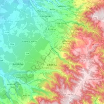
Name: Cittanova topographic map, elevation, terrain.
Location: Cittanova, Reggio Calabria, Calabria, 89022, Italy (38.29537 16.00404 38.45003 16.14346)
Average elevation: 436 m
Minimum elevation: 76 m
Maximum elevation: 1,007 m
Thank you for supporting this site ❤️
Make a donation
Make a donation
Other topographic maps
Click on a map to view its topography, its elevation and its terrain.