
Thank you for supporting this site ❤️
Make a donation
Make a donation
18th district topographic map
Click on the map to display elevation.
Thank you for supporting this site ❤️
Make a donation
Make a donation
About this map
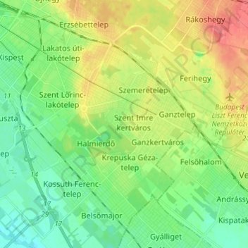
Name: 18th district topographic map, elevation, terrain.
Location: 18th district, Budapest, Central Hungary, Hungary (47.38537 19.15410 47.46729 19.26577)
Average elevation: 127 m
Minimum elevation: 105 m
Maximum elevation: 163 m
Thank you for supporting this site ❤️
Make a donation
Make a donation
Other topographic maps
Click on a map to view its topography, its elevation and its terrain.
Thank you for supporting this site ❤️
Make a donation
Make a donation
Thank you for supporting this site ❤️
Make a donation
Make a donation