
Thank you for supporting this site ❤️
Make a donation
Make a donation
Poplar Bluff topographic map
Click on the map to display elevation.
Thank you for supporting this site ❤️
Make a donation
Make a donation
About this map
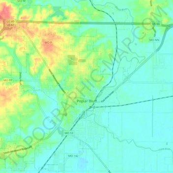
Name: Poplar Bluff topographic map, elevation, terrain.
Location: Poplar Bluff, Butler County, Missouri, 63901, United States (36.72138 -90.45631 36.80633 -90.36411)
Average elevation: 112 m
Minimum elevation: 95 m
Maximum elevation: 158 m
Thank you for supporting this site ❤️
Make a donation
Make a donation
Other topographic maps
Click on a map to view its topography, its elevation and its terrain.