
Fresnay topographic map
Interactive map
Click on the map to display elevation.
About this map
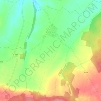
Name: Fresnay topographic map, elevation, terrain.
Average elevation: 233 m
Minimum elevation: 186 m
Maximum elevation: 288 m
Other topographic maps
Click on a map to view its topography, its elevation and its terrain.
Clairvaux
France > Grand Est > Aube > Ville-sous-la-Ferté
Clairvaux, Ville-sous-la-Ferté, Bar-sur-Aube, Aube, Grand Est, France métropolitaine, 10310, France
Average elevation: 238 m
L'Ecole Militaire
France > Grand Est > Aube > Brienne-le-Château
L'Ecole Militaire, Brienne-le-Château, Bar-sur-Aube, Aube, Grand Est, France métropolitaine, 10500, France
Average elevation: 130 m
Saint-Hyppolite
France > Grand Est > Aube > La Rivière-de-Corps
Saint-Hyppolite, La Rivière-de-Corps, Troyes, Aube, Grand Est, France métropolitaine, 10440, France
Average elevation: 124 m
Massonville
France > Grand Est > Aube > Feuges
Massonville, Feuges, Troyes, Aube, Grand Est, France métropolitaine, 10150, France
Average elevation: 166 m