
La Tène topographic map
Interactive map
Click on the map to display elevation.
About this map
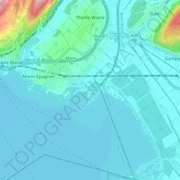
Name: La Tène topographic map, elevation, terrain.
Location: La Tène, District de Neuchâtel, Neuchâtel, Suisse (46.97952 6.99314 47.03091 7.04034)
Average elevation: 444 m
Minimum elevation: 422 m
Maximum elevation: 631 m
Other topographic maps
Click on a map to view its topography, its elevation and its terrain.
Marin-Epagnier
Suisse > Neuchâtel > La Tène > Marin-Epagnier
Marin-Epagnier, La Tène, Neuchâtel, 2074, Suisse
Average elevation: 458 m