
Thank you for supporting this site ❤️
Make a donation
Make a donation
Békásmegyer topographic map
Click on the map to display elevation.
Thank you for supporting this site ❤️
Make a donation
Make a donation
About this map
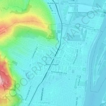
Name: Békásmegyer topographic map, elevation, terrain.
Location: Békásmegyer, 3rd district, Budapest, Central Hungary, Hungary (47.59123 19.03054 47.61010 19.07672)
Average elevation: 127 m
Minimum elevation: 98 m
Maximum elevation: 251 m
Thank you for supporting this site ❤️
Make a donation
Make a donation
Other topographic maps
Click on a map to view its topography, its elevation and its terrain.
Thank you for supporting this site ❤️
Make a donation
Make a donation
Thank you for supporting this site ❤️
Make a donation
Make a donation