Geolocate
👉 Easily get elevation data in JSON, GeoTIFF and KML formats using Elevation API
Thank you for supporting this site ❤️
Make a donation

Magalas topographic map

Click on the map to display elevation.

👉 Easily get elevation data in JSON, GeoTIFF and KML formats using Elevation API
Thank you for supporting this site ❤️
Make a donation

About this map

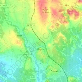
Name: Magalas topographic map, elevation, terrain.

Location: Magalas, Béziers, Hérault, Occitania, Metropolitan France, 34480, France (43.45068 3.18424 43.50494 3.25906)

Average elevation: 123 m

Minimum elevation: 71 m

Maximum elevation: 218 m

Other topographic maps

Click on a map to view its topography, its elevation and its terrain.

Saint-Jean d'Aureilhan

France > Occitania > Hérault > Béziers

Average elevation: 39 m

Portiragnes Plage

France > Occitania > Hérault > Portiragnes

Average elevation: 2 m

Rabieux

France > Occitania > Hérault > Ceyras

Average elevation: 123 m

Montpellier

France > Occitania > Hérault > Montpellier

Average elevation: 72 m

Boissezon

France > Occitania > Hérault > Vieussan

Average elevation: 273 m

Place de la Mairie

France > Occitania > Hérault > Marseillan

Average elevation: 7 m

Ceps

France > Occitania > Hérault > Roquebrun

Average elevation: 216 m