
Pâquis topographic map
Interactive map
Click on the map to display elevation.
About this map
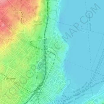
Name: Pâquis topographic map, elevation, terrain.
Location: Pâquis, Genève, 1202, Suisse (46.20776 6.12826 46.23189 6.15654)
Average elevation: 395 m
Minimum elevation: 368 m
Maximum elevation: 469 m
Other topographic maps
Click on a map to view its topography, its elevation and its terrain.
Parc Geisendorf
Parc Geisendorf, Grottes et Saint-Gervais, Genève, Suisse
Average elevation: 407 m
Parc des Eaux-Vives
Parc des Eaux-Vives, Eaux-Vives, Genève, Suisse
Average elevation: 402 m
Grottes et Saint-Gervais
Grottes et Saint-Gervais, Genève, Suisse
Average elevation: 403 m
Petit-Saconnex et Servette
Petit-Saconnex et Servette, Genève, 1209, Suisse
Average elevation: 426 m