
Thank you for supporting this site ❤️
Make a donation
Make a donation
Río de Oro topographic map
Click on the map to display elevation.
Thank you for supporting this site ❤️
Make a donation
Make a donation
About this map
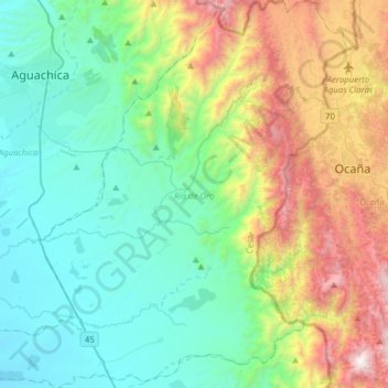
Name: Río de Oro topographic map, elevation, terrain.
Location: Río de Oro, Cesar, Colombia (8.06089 -73.65499 8.36804 -73.35844)
Average elevation: 1,081 m
Minimum elevation: 98 m
Maximum elevation: 2,290 m
Thank you for supporting this site ❤️
Make a donation
Make a donation
Other topographic maps
Click on a map to view its topography, its elevation and its terrain.