
Thank you for supporting this site ❤️
Make a donation
Make a donation
Outer Nanaimo Harbour topographic map
Click on the map to display elevation.
Thank you for supporting this site ❤️
Make a donation
Make a donation
About this map
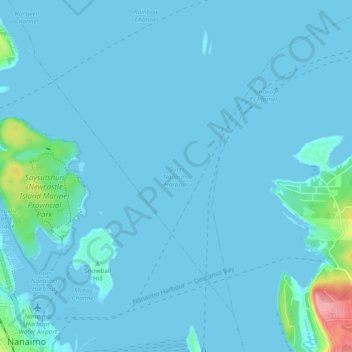
Name: Outer Nanaimo Harbour topographic map, elevation, terrain.
Average elevation: 7 m
Minimum elevation: -1 m
Maximum elevation: 110 m
Thank you for supporting this site ❤️
Make a donation
Make a donation
Other topographic maps
Click on a map to view its topography, its elevation and its terrain.
Cathers Lake
Canada > British Columbia > Regional District of Nanaimo > Nanaimo
Average elevation: 119 m
East Wellington Park
Canada > British Columbia > Regional District of Nanaimo > Nanaimo
Average elevation: 99 m
Colinwood Park
Canada > British Columbia > Regional District of Nanaimo > Nanaimo
Average elevation: 104 m
Thank you for supporting this site ❤️
Make a donation
Make a donation