
Middlesex County topographic map
Click on the map to display elevation.
Middlesex County
Bisected by the Raritan River, the county is topographically typical of Central Jersey in that it is largely flat. The majority of the county is located on the inner coastal plain, with the remainder of the county being located on the Eastern Piedmont. The elevation ranges from sea level to 300 feet (91 m) above sea level on a hill scaled by Major Road/ Sand Hill Road near Route 1 in South Brunswick Township.
About this map
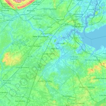
Name: Middlesex County topographic map, elevation, terrain.
Location: Middlesex County, New Jersey, United States (40.25112 -74.63093 40.60899 -74.20369)
Average elevation: 28 m
Minimum elevation: -3 m
Maximum elevation: 182 m
Other topographic maps
Click on a map to view its topography, its elevation and its terrain.
North Stelton
United States > New Jersey > Middlesex County > Piscataway Township
Average elevation: 29 m