
Chefchaouen topographic map
Interactive map
Click on the map to display elevation.
About this map
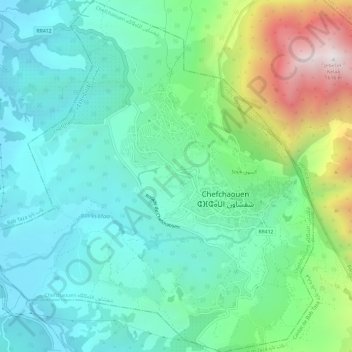
Name: Chefchaouen topographic map, elevation, terrain.
Average elevation: 619 m
Minimum elevation: 279 m
Maximum elevation: 1,600 m
Chefchaouen ou Chaouen (arabe. شفشاون /ʃəfˈʃɑˑwən/, berbère. ⴰⵛⵛⴰⵡⴻⵏ /ɑʃʃɑwən/) est une ville du nord-ouest du Maroc, bâtie à 600 m d'altitude au pied des monts Kelaa et Meggou, sur la chaîne du Rif. Elle est le chef-lieu de la province homonyme. Sa population est de 42 786 habitants.
Other topographic maps
Click on a map to view its topography, its elevation and its terrain.
Chefchaouen
Chefchaouen, Province de Chefchaouen, Tanger-Tétouan-Al Hoceima, 91004, Maroc
Average elevation: 766 m