
Champaign County topographic map
Interactive map
Click on the map to display elevation.
About this map
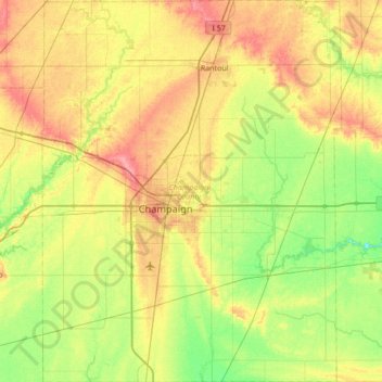
Name: Champaign County topographic map, elevation, terrain.
Location: Champaign County, Illinois, United States of America (39.87910 -88.46357 40.40068 -87.92882)
Average elevation: 217 m
Minimum elevation: 187 m
Maximum elevation: 260 m
The topography of Champaign County was formed by the Wisconsin Glacier about 20,000 years before the present. Lobes of ice from what is now Lake Michigan crossed the county, creating a deep pile of glacial soil, up to 300 feet thick, topped by numerous moraines forming small, flat watersheds with no outlets.
Other topographic maps
Click on a map to view its topography, its elevation and its terrain.
Marshall County
United States of America > Illinois
Marshall County, Illinois, United States of America
Average elevation: 201 m
Richland County
United States of America > Illinois
Richland County, Illinois, United States of America
Average elevation: 145 m
Monroe County
United States of America > Illinois
Monroe County, Illinois, United States of America
Average elevation: 157 m
Springfield
United States of America > Illinois > Springfield
Springfield, Sangamon County, Illinois, United States of America
Average elevation: 178 m
Vergennes
United States of America > Illinois > Vergennes > Vergennes
Vergennes, Jackson County, Illinois, United States of America
Average elevation: 121 m
Gallatin County
United States of America > Illinois
Gallatin County, Illinois, United States of America
Average elevation: 122 m
DeKalb County
United States of America > Illinois
DeKalb County, Illinois, United States of America
Average elevation: 253 m
Henry County
United States of America > Illinois
Henry County, Illinois, United States of America
Average elevation: 214 m
Alexander County
United States of America > Illinois
Alexander County, Illinois, United States of America
Average elevation: 112 m