
Thank you for supporting this site ❤️
Make a donation
Make a donation
Mont Brisé topographic map
Click on the map to display elevation.
Thank you for supporting this site ❤️
Make a donation
Make a donation
About this map
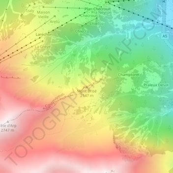
Name: Mont Brisé topographic map, elevation, terrain.
Location: Mont Brisé, Courmayeur, Valle d'Aosta, 11013, Italia (45.77843 6.94291 45.77853 6.94301)
Average elevation: 1,970 m
Minimum elevation: 1,221 m
Maximum elevation: 2,735 m
Thank you for supporting this site ❤️
Make a donation
Make a donation
Other topographic maps
Click on a map to view its topography, its elevation and its terrain.