
Solidaridad topographic map
Click on the map to display elevation.
Solidaridad
Like most of the Yucatan Peninsula, Solidaridad is almost entirely flat with a gentle slope towards the sea, so from west to east, most of the area never reaches an altitude above 25 metres (82 ft) above sea level.
About this map
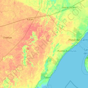
Name: Solidaridad topographic map, elevation, terrain.
Location: Solidaridad, Quintana Roo, Mexico (20.35686 -87.96274 20.81206 -86.92063)
Average elevation: 13 m
Minimum elevation: -3 m
Maximum elevation: 31 m
Other topographic maps
Click on a map to view its topography, its elevation and its terrain.