
Thank you for supporting this site ❤️
Make a donation
Make a donation
La Cabaña topographic map
Click on the map to display elevation.
Thank you for supporting this site ❤️
Make a donation
Make a donation
About this map
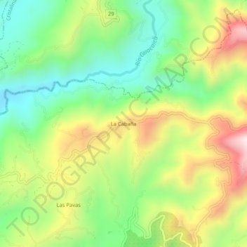
Name: La Cabaña topographic map, elevation, terrain.
Average elevation: 1,266 m
Minimum elevation: 999 m
Maximum elevation: 1,653 m
Thank you for supporting this site ❤️
Make a donation
Make a donation
Other topographic maps
Click on a map to view its topography, its elevation and its terrain.
Comuna Atardeceres
Colombia > Caldas > Manizales > Perímetro Urbano Manizales
Average elevation: 1,913 m
Comuna Ecoturística Cerro de Oro
Colombia > Caldas > Manizales > Perímetro Urbano Manizales
Average elevation: 2,174 m
Thank you for supporting this site ❤️
Make a donation
Make a donation
Comuna Universitaria
Colombia > Caldas > Manizales > Perímetro Urbano Manizales
Average elevation: 1,977 m
Comuna Ecoturística Cerro de Oro
Colombia > Caldas > Manizales > Perímetro Urbano Manizales
Average elevation: 2,174 m
Comuna Universitaria
Colombia > Caldas > Manizales > Perímetro Urbano Manizales
Average elevation: 1,977 m
Thank you for supporting this site ❤️
Make a donation
Make a donation
Comuna Ecoturística Cerro de Oro
Colombia > Caldas > Manizales > Perímetro Urbano Manizales
Average elevation: 2,174 m