
Thank you for supporting this site ❤️
Make a donation
Make a donation
Egg Harbor City topographic map
Click on the map to display elevation.
Thank you for supporting this site ❤️
Make a donation
Make a donation
About this map
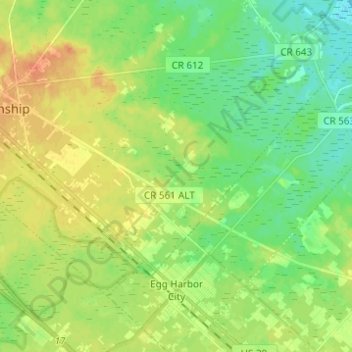
Name: Egg Harbor City topographic map, elevation, terrain.
Location: Egg Harbor City, Atlantic County, New Jersey, United States (39.51855 -74.65681 39.60013 -74.53379)
Average elevation: 16 m
Minimum elevation: -1 m
Maximum elevation: 35 m
Thank you for supporting this site ❤️
Make a donation
Make a donation
Other topographic maps
Click on a map to view its topography, its elevation and its terrain.
Mullica Township
United States > New Jersey > Atlantic County > Mullica Township
Average elevation: 22 m
Thank you for supporting this site ❤️
Make a donation
Make a donation
Thank you for supporting this site ❤️
Make a donation
Make a donation
English Creek
United States > New Jersey > Atlantic County > Egg Harbor Township > English Creek
Average elevation: 5 m
Thank you for supporting this site ❤️
Make a donation
Make a donation
Egg Harbor Township
United States > New Jersey > Atlantic County > Egg Harbor Township
Average elevation: 13 m