
Make a donation
Scotch Creek topographic map
Click on the map to display elevation.
Make a donation
About this map
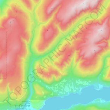
Name: Scotch Creek topographic map, elevation, terrain.
Average elevation: 1,125 m
Minimum elevation: 340 m
Maximum elevation: 2,114 m
Make a donation
Other topographic maps
Click on a map to view its topography, its elevation and its terrain.
Shuswap Lake
Canada > British Columbia > Columbia-Shuswap Regional District > Area F (Scotch Creek/Seymour Arm)
Average elevation: 1,064 m
Anglemont
Canada > British Columbia > Columbia-Shuswap Regional District > Area F (Scotch Creek/Seymour Arm)
Average elevation: 472 m
Magna Bay
Canada > British Columbia > Columbia-Shuswap Regional District > Area F (Scotch Creek/Seymour Arm)
Average elevation: 412 m
Celista
Canada > British Columbia > Columbia-Shuswap Regional District > Area F (Scotch Creek/Seymour Arm)
Average elevation: 407 m
Make a donation
Love Hump
Canada > British Columbia > Columbia-Shuswap Regional District > Area F (Scotch Creek/Seymour Arm)
Average elevation: 1,771 m
Seymour Arm
Canada > British Columbia > Columbia-Shuswap Regional District > Area F (Scotch Creek/Seymour Arm)
Average elevation: 381 m