
Mortier topographic map
Click on the map to display elevation.
About this map
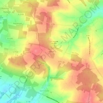
Name: Mortier topographic map, elevation, terrain.
Average elevation: 127 m
Minimum elevation: 79 m
Maximum elevation: 162 m
Other topographic maps
Click on a map to view its topography, its elevation and its terrain.
Rouillac
France > Nouvelle-Aquitaine > Charente > Rouillac
Le relief de la commune est celui d'un plateau relativement élevé, avec la tête de la vallée de la Nouère qui le traverse au centre. Le point culminant est à une altitude de 185 m, situé au nord de la commune entre le Temple et le château de Lignères. C'est aussi le point culminant de toute cette…
Average elevation: 130 m
Gourville
France > Nouvelle-Aquitaine > Charente > Rouillac
Le relief de la commune est celui de plateaux assez vallonnés dans une grande partie sud, et d'une plaine au nord d'une altitude moyenne de 80 m. Le point culminant est à une altitude de 155 m, situé sur la limite sud près du château de Lignères. Le point le plus bas est à 55 m, situé sur la limite…
Average elevation: 90 m
Sonneville
France > Nouvelle-Aquitaine > Charente > Rouillac
Le relief est celui d'un plateau légèrement incliné vers le sud-ouest, d'une altitude moyenne relativement élevée de 130 m. Le point culminant de la commune est à une altitude de 162 m, situé sur la limite sud-est près de la Fuie. Le point le plus bas est à 68 m, situé à l'ouest sur la limite…
Average elevation: 127 m
Rouillac
France > Nouvelle-Aquitaine > Charente > Rouillac
Le relief de la commune est celui d'un plateau relativement élevé, avec la tête de la vallée de la Nouère qui le traverse au centre. Le point culminant est à une altitude de 185 m, situé au nord de la commune entre le Temple et le château de Lignères. C'est aussi le point culminant de toute cette…
Average elevation: 130 m