
Garland County topographic map
Interactive map
Click on the map to display elevation.
About this map
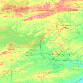
Name: Garland County topographic map, elevation, terrain.
Location: Garland County, Arkansas, United States of America (34.38914 -93.40716 34.77353 -92.79146)
Average elevation: 224 m
Minimum elevation: 68 m
Maximum elevation: 587 m
Other topographic maps
Click on a map to view its topography, its elevation and its terrain.
Cleburne County
United States of America > Arkansas
Cleburne County, Arkansas, United States of America
Average elevation: 223 m
Mount Ida
United States of America > Arkansas > Mount Ida
Mount Ida, Montgomery County, Arkansas, United States of America
Average elevation: 215 m