
Thank you for supporting this site ❤️
Make a donation
Make a donation
Will County topographic map
Click on the map to display elevation.
Thank you for supporting this site ❤️
Make a donation
Make a donation
About this map
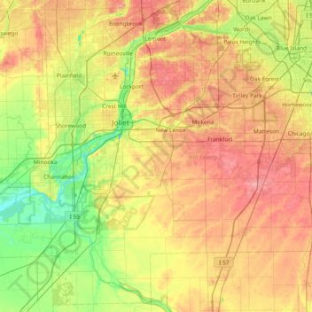
Name: Will County topographic map, elevation, terrain.
Location: Will County, Illinois, United States (41.20159 -88.26195 41.72903 -87.52565)
Average elevation: 199 m
Minimum elevation: 149 m
Maximum elevation: 263 m
Thank you for supporting this site ❤️
Make a donation
Make a donation
Other topographic maps
Click on a map to view its topography, its elevation and its terrain.
Sturbridge Village
United States > Illinois > Winnebago County > Sturbridge Village
Average elevation: 230 m
Thank you for supporting this site ❤️
Make a donation
Make a donation