
Make a donation
Saint-Nazaire topographic map
Click on the map to display elevation.
Make a donation
Saint-Nazaire
According to INSEE, Saint-Nazaire is the commune-center of an urban unit (commonly: agglomeration) which counted 186,760 inhabitants in 2018, gathering 17 communes of the Loire estuary. This unit is the urban center of the urban area of Saint-Nazaire (24 communes), which had 213,675 inhabitants in 2018 and extending over Brière and almost all of the Guérande peninsula. The eastern part of the town is on the alluvial terrain between the Brière and the Loire estuary. The western part, more extensive, corresponds to the extension of the hillside of Guérande: the relief is hilly and of higher altitude, where one finds a granite and metamorphic base. Geologically, Saint-Nazaire is located in the Armorican massif.
Make a donation
About this map
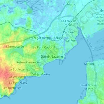
Name: Saint-Nazaire topographic map, elevation, terrain.
Average elevation: 6 m
Minimum elevation: -5 m
Maximum elevation: 46 m
Make a donation
Other topographic maps
Click on a map to view its topography, its elevation and its terrain.
Make a donation
Le Champsiome
France > Pays de la Loire > Loire-Atlantique > Pont-Saint-Martin
Average elevation: 24 m
Make a donation
Make a donation
Le Petit Haut Bodio
France > Pays de la Loire > Loire-Atlantique > Pontchâteau
Average elevation: 21 m
Make a donation
Le Hameau du Petit Raffuneau
France > Pays de la Loire > Loire-Atlantique > Orvault
Average elevation: 51 m
Make a donation
La Vilhouette
France > Pays de la Loire > Loire-Atlantique > Loireauxence > La Vilhouette
Average elevation: 18 m
Make a donation