
Thank you for supporting this site ❤️
Make a donation
Make a donation
Petroșani topographic map
Click on the map to display elevation.
Thank you for supporting this site ❤️
Make a donation
Make a donation
About this map
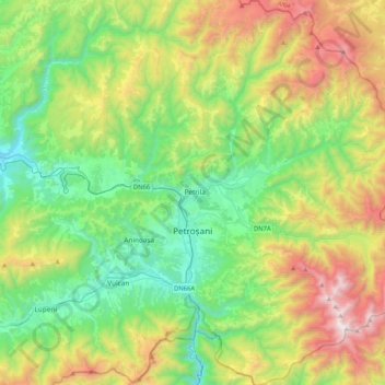
Name: Petroșani topographic map, elevation, terrain.
Location: Petroșani, Hunedoara, Romania (45.29752 23.25975 45.58814 23.53915)
Average elevation: 1,137 m
Minimum elevation: 481 m
Maximum elevation: 2,502 m
Thank you for supporting this site ❤️
Make a donation
Make a donation
Other topographic maps
Click on a map to view its topography, its elevation and its terrain.