
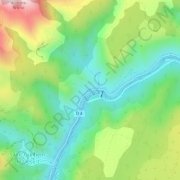
Source du Cabrier topographic map
Interactive map
Click on the map to display elevation.
About this map
Name: Source du Cabrier topographic map, elevation, terrain.
Average elevation: 230 m
Minimum elevation: 62 m
Maximum elevation: 534 m
Other topographic maps
Click on a map to view its topography, its elevation and its terrain.
Menhir des Lavagnes
France > Occitanie > Hérault > Saint-Guilhem-le-Désert
Menhir des Lavagnes, D 122, Lavagnes, Saint-Guilhem-le-Désert, Lodève, Hérault, Occitanie, France métropolitaine, 34150, France
Average elevation: 593 m
Le Roi Platane
France > Occitanie > Hérault > Saint-Guilhem-le-Désert
Le Roi Platane, Place de la Liberté, Saint-Guilhem-le-Désert, Lodève, Hérault, Occitanie, France métropolitaine, 34150, France
Average elevation: 245 m