
Hunau topographic map
Interactive map
Click on the map to display elevation.
About this map
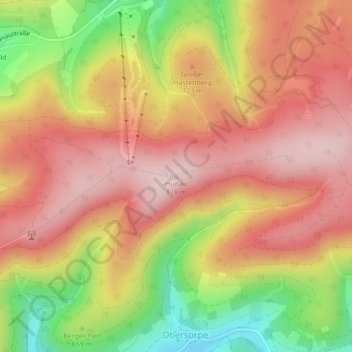
Name: Hunau topographic map, elevation, terrain.
Average elevation: 699 m
Minimum elevation: 520 m
Maximum elevation: 817 m
Other topographic maps
Click on a map to view its topography, its elevation and its terrain.
Gellinghausen
Duitsland > Noordrijn-Westfalen > Schmallenberg > Gellinghausen
Gellinghausen, Schmallenberg, Hochsauerlandkreis, Noordrijn-Westfalen, Duitsland
Average elevation: 565 m
Lengenbeck
Duitsland > Noordrijn-Westfalen > Schmallenberg > Lengenbeck
Lengenbeck, Schmallenberg, Hochsauerlandkreis, Noordrijn-Westfalen, Duitsland
Average elevation: 590 m