
Thank you for supporting this site ❤️
Make a donation
Make a donation
Bijombo topographic map
Click on the map to display elevation.
Thank you for supporting this site ❤️
Make a donation
Make a donation
About this map
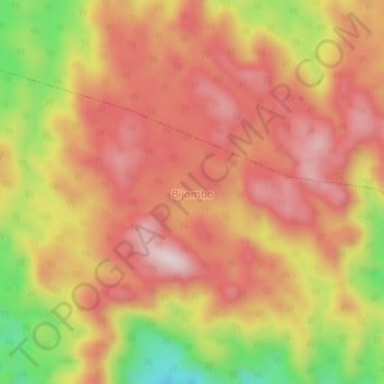
Name: Bijombo topographic map, elevation, terrain.
Location: Bijombo, Mwenga, South Kivu, Democratic Republic of the Congo (-3.36878 28.49485 -3.32878 28.53485)
Average elevation: 1,888 m
Minimum elevation: 1,612 m
Maximum elevation: 2,055 m
Thank you for supporting this site ❤️
Make a donation
Make a donation