
Make a donation
Tagliamento topographic map
Click on the map to display elevation.
Make a donation
Tagliamento
The source is at an elevation of 1,195 metres (3,921 ft) in the Veneto region (Lorenzago di Cadore) in the Province of Belluno near the border with the Province of Udine, north-west of Forni di Sopra close to the Mauria Pass. Initially, the river's course is in a west to east direction, parallel to the Carnic Alps range. The first tributary of note is the Lumiei, which enters the Tagliamento from the left at a distance of 26 kilometres (16 mi) from the source.
Make a donation
About this map
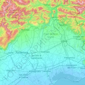
Name: Tagliamento topographic map, elevation, terrain.
Location: Tagliamento, Friuli – Venezia Giulia, Italy (45.64400 12.52147 46.44997 13.13929)
Average elevation: 390 m
Minimum elevation: -6 m
Maximum elevation: 2,706 m
Make a donation
Other topographic maps
Click on a map to view its topography, its elevation and its terrain.
Albana / Ibána / Albane
Italy > Friuli – Venezia Giulia > Udine / Udin / Videm > Prepotto / Prapotno / Prepot
Average elevation: 175 m
Tribil Superiore / Gorenji Tarbij
Italy > Friuli – Venezia Giulia > Udine > Stregna
Average elevation: 500 m
Make a donation
Erto / Nert
Italy > Friuli – Venezia Giulia > Pordenone / Pordenon > Erto e Casso
Average elevation: 1,112 m
Scale / Skale
Italy > Friuli – Venezia Giulia > Udine / Udin / Videm > Drenchia
Average elevation: 610 m
Make a donation
Montemaggiore / Brezje
Italy > Friuli – Venezia Giulia > Udine / Udin / Videm > Taipana
Average elevation: 817 m
Make a donation
Make a donation
Make a donation
Make a donation
Bannia / Banìe
Italy > Friuli – Venezia Giulia > Pordenone / Pordenon > Fiume Veneto
Average elevation: 21 m
Zegla / Ceglo
Italy > Friuli – Venezia Giulia > Gorizia / Gurize / Gorica > Cormons / Cormòns / Krmin
Average elevation: 85 m
Monte Tamai
Italy > Friuli – Venezia Giulia > Udine / Udin / Videm > Ovaro / Davâr
Average elevation: 1,588 m
Make a donation
Timau / Tischlbong
Italy > Friuli – Venezia Giulia > Udine > Paluzza / Paluce / Palutsch
Average elevation: 1,307 m
Sauris di Sopra / Plozn / Sauris Disore
Italy > Friuli – Venezia Giulia > Udine
Average elevation: 1,469 m
Make a donation
Monte Lubia / Ljubija
Italy > Friuli – Venezia Giulia > Udine / Udin / Videm > Pulfero
Average elevation: 795 m
Sandrine
Italy > Friuli – Venezia Giulia > Udine / Udin / Videm > Artegna / Dartigne > Borc dal Steli
Average elevation: 263 m