
Stromness topographic map
Interactive map
Click on the map to display elevation.
About this map
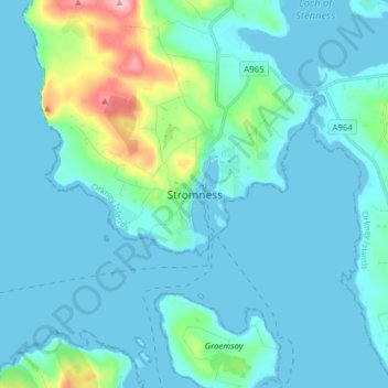
Name: Stromness topographic map, elevation, terrain.
Average elevation: 21 m
Minimum elevation: -1 m
Maximum elevation: 157 m
Other topographic maps
Click on a map to view its topography, its elevation and its terrain.
Orphir
Vereinigtes Königreich > Schottland > Orkney > Orphir
Orphir, Orkney, Schottland, KW17 2RQ, Vereinigtes Königreich
Average elevation: 64 m
Whitehall
Vereinigtes Königreich > Schottland > Orkney
Whitehall, Orkney, Schottland, KW17 2AR, Vereinigtes Königreich
Average elevation: 5 m