
Thank you for supporting this site ❤️
Make a donation
Make a donation
Topaz Mountain topographic map
Click on the map to display elevation.
Thank you for supporting this site ❤️
Make a donation
Make a donation
About this map
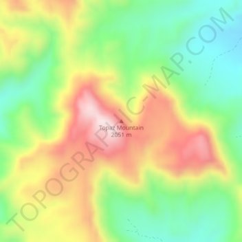
Name: Topaz Mountain topographic map, elevation, terrain.
Location: Topaz Mountain, Juab County, Utah, United States (39.70934 -113.10335 39.70944 -113.10325)
Average elevation: 1,895 m
Minimum elevation: 1,696 m
Maximum elevation: 2,144 m
Thank you for supporting this site ❤️
Make a donation
Make a donation
Other topographic maps
Click on a map to view its topography, its elevation and its terrain.
Deep Creek Mountains Wilderness Study Area
United States > Utah > Juab County
Average elevation: 1,887 m
Mona
United States > Utah > Juab County
Mount Nebo, the southernmost and highest mountain in the Wasatch Range, rises 5 miles (8 km) east of Mona to an elevation of 11,928 feet (3,636 m).
Average elevation: 1,524 m
Thank you for supporting this site ❤️
Make a donation
Make a donation