
Thank you for supporting this site ❤️
Make a donation
Make a donation
Glen Allen topographic map
Click on the map to display elevation.
Thank you for supporting this site ❤️
Make a donation
Make a donation
About this map
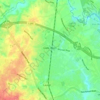
Name: Glen Allen topographic map, elevation, terrain.
Location: Glen Allen, Henrico County, Virginia, United States (37.63523 -77.52748 37.69417 -77.44831)
Average elevation: 62 m
Minimum elevation: 31 m
Maximum elevation: 89 m
Thank you for supporting this site ❤️
Make a donation
Make a donation
Other topographic maps
Click on a map to view its topography, its elevation and its terrain.
Laurel West
United States > Virginia > Henrico County > Glen Allen > Laurel West
Average elevation: 64 m