
Thank you for supporting this site ❤️
Make a donation
Make a donation
El Centenario topographic map
Click on the map to display elevation.
Thank you for supporting this site ❤️
Make a donation
Make a donation
About this map
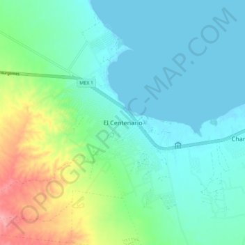
Name: El Centenario topographic map, elevation, terrain.
Average elevation: 25 m
Minimum elevation: -2 m
Maximum elevation: 104 m
Thank you for supporting this site ❤️
Make a donation
Make a donation
Other topographic maps
Click on a map to view its topography, its elevation and its terrain.
El Centenario
Mexico > Baja California Sur > Municipio de La Paz > El Centenario
Average elevation: 16 m
Thank you for supporting this site ❤️
Make a donation
Make a donation