
Thank you for supporting this site ❤️
Make a donation
Make a donation
Riverton topographic map
Click on the map to display elevation.
Thank you for supporting this site ❤️
Make a donation
Make a donation
About this map
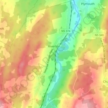
Name: Riverton topographic map, elevation, terrain.
Average elevation: 76 m
Minimum elevation: 3 m
Maximum elevation: 141 m
Thank you for supporting this site ❤️
Make a donation
Make a donation
Other topographic maps
Click on a map to view its topography, its elevation and its terrain.
Their Light Shall Always Shine Memorial Park
Canada > Nova Scotia > Municipality of Pictou County > Priestville
Average elevation: 32 m