
Make a donation
Swabi topographic map
Click on the map to display elevation.
Make a donation
About this map
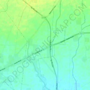
Name: Swabi topographic map, elevation, terrain.
Location: Swabi, Khyber Pakhtunkhwa, Pakistan (34.20152 72.08258 34.24152 72.12258)
Average elevation: 311 m
Minimum elevation: 303 m
Maximum elevation: 319 m
Make a donation
Other topographic maps
Click on a map to view its topography, its elevation and its terrain.
Swat District
The average elevation of Swat is 980 m (3,220 ft), resulting in a considerably cooler and wetter climate compared to the rest of Pakistan. With lush forests, verdant alpine meadows, and snow-capped mountains, Swat is one of the country's most popular tourist destinations.
Average elevation: 2,674 m
Lower Chitral District
Pakistan > Khyber Pakhtunkhwa > Former Chitrāl District
Average elevation: 3,685 m
Torghar District
Machai Sar or Machai Peak is the highest peak of Torghar mountain at an altitude of 9,755 feet from the Mean sea level. Machai Sar Meadows is located northwest of Oghi Town of Mansehra District, near Machai Dhanda or Danda. The conference was less popular because it was located in the remote area of Mansehra…
Average elevation: 1,321 m
Make a donation
Kurram River
Generally, the topography of the catchment area of the Kurrama River is mountainous in the upper reaches near Ali Khayl, Mirazi Kalay, Peer Kalai, Kharlachi, Parachinar and Thal areas. Near Bannu city, the river flattens up and follows a consistent mild slope up to its outfall in to the Indus River near Isa…
Average elevation: 436 m
Kalam Tehsil
At an elevation about 2,000 m (6,600 ft) above sea level, the valley itself provides a plateau that is located above the river and is used for farming. There are a number of visible mountains, also visible from Matiltan, a valley close to Kalam Valley, including Mount Falaksar 5,918 meters (19,416 feet), and…
Average elevation: 3,920 m
Make a donation
Lakki Marwat
Pakistan > Khyber Pakhtunkhwa > Lakki Marwat
The district is a combination of hills and sandy plains. The hilly areas are along the boundaries of the district especially in the east, southeast, southwest and northwest. In the southeast, the Marwat range separates Lakki Marwat from Dera Ismail Khan District while in the east the Karak Niazi range…
Average elevation: 345 m
Gantar Khwar
Pakistan > Khyber Pakhtunkhwa > Battagram District > Allai Tehsil > Palang
Average elevation: 2,082 m
Make a donation
North Waziristan District
Pakistan > Khyber Pakhtunkhwa > North Waziristan District
Average elevation: 1,469 m