Banago topographic map
Interactive map
Click on the map to display elevation.
About this map
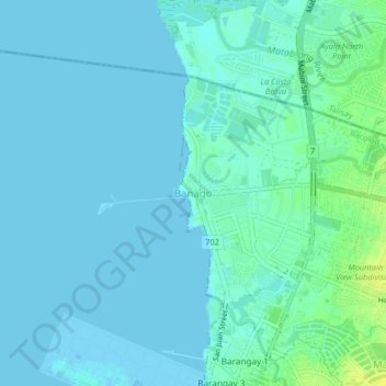
Name: Banago topographic map, elevation, terrain.
Location: Banago, Bacolod, Western Visayas, 6100, Philippines (10.68392 122.92959 10.72392 122.96959)
Average elevation: 4 m
Minimum elevation: -1 m
Maximum elevation: 18 m
Other topographic maps
Click on a map to view its topography, its elevation and its terrain.
Taculing
Taculing, Bacolod, Western Visayas, 6100, Philippines
Average elevation: 19 m
Granada
Granada, Bacolod-1, Bacolod, Western Visayas, Philippines
Average elevation: 156 m
Tangub
Tangub, Bacolod-2, Bacolod, Western Visayas, Philippines
Average elevation: 10 m
Vista Alegre
Vista Alegre, Bacolod-1, Bacolod, Western Visayas, 6100, Philippines
Average elevation: 63 m
Barangay 27
Barangay 27, City Proper, Bacolod, Western Visayas, Philippines
Average elevation: 18 m
Barangay 29
Barangay 29, City Proper, Bacolod, Western Visayas, Philippines
Average elevation: 12 m
Barangay 34
Barangay 34, City Proper, Bacolod, Western Visayas, Philippines
Average elevation: 5 m