
Make a donation
Sverdlovsk Oblast topographic map
Click on the map to display elevation.
Make a donation
Sverdlovsk Oblast
The highest mountains all rise in the North Urals, Konzhakovsky Kamen at 1,569 metres (5,148 ft) and Denezhkin Kamen at 1,492 metres (4,895 ft). The Middle Urals is mostly hilly country with no discernible peaks; the mean elevation is closer to 300 to 500 metres (980 to 1,640 ft) above sea level. Principal rivers include the Tavda, the Tura, the Chusovaya, and the Ufa, the latter two being tributaries of the Kama.
Make a donation
About this map
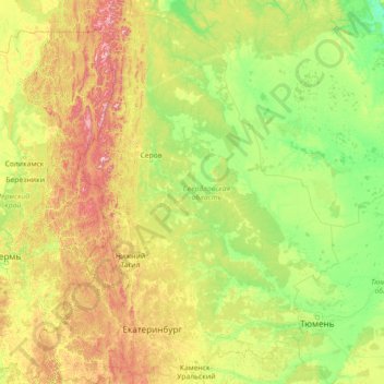
Name: Sverdlovsk Oblast topographic map, elevation, terrain.
Location: Sverdlovsk Oblast, Ural Federal District, Russia (56.05322 57.22655 61.94662 66.18486)
Average elevation: 174 m
Minimum elevation: 13 m
Maximum elevation: 1,452 m
Make a donation
Other topographic maps
Click on a map to view its topography, its elevation and its terrain.
Make a donation
Make a donation
Make a donation
Make a donation
Make a donation
Astrakhan
Russia > Astrakhan Oblast > Astrakhan > Astrakhan
Astrakhan (Russian: Астрахань, tr. Astrakhan', IPA: ; Tatar: Cyrillic Әстерхан, Latin Ästerxan), is the largest city and administrative centre of Astrakhan Oblast in Southern Russia. The city lies on two banks of the Volga, in the upper part of the Volga Delta, on eleven islands of the…
Average elevation: -21 m
Tynda
Russia > Amur Oblast > городской округ Тында
The town is located at an elevation of 500 meters (1,600 ft) above sea level, near where the Getkan joins the Tynda River, after which the town was named. The Tynda then flows into the Gilyuy, a tributary of the Zeya, a few kilometers east of the town.
Average elevation: 566 m
Make a donation
Yekaterinburg
Russia > Sverdlovsk Oblast > Yekaterinburg Municipality > Yekaterinburg
Average elevation: 274 m
Make a donation
Make a donation
Ob
Russia > Yamalo-Nenets Autonomous Okrug > городской округ Лабытнанги > Labytnangi
Average elevation: 6 m
Make a donation