
Bitche topographic map
Interactive map
Click on the map to display elevation.
About this map
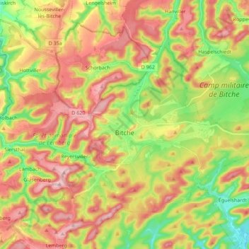
Name: Bitche topographic map, elevation, terrain.
Average elevation: 331 m
Minimum elevation: 232 m
Maximum elevation: 427 m
Other topographic maps
Click on a map to view its topography, its elevation and its terrain.
Marange-Silvange
Marange-Silvange, Metz, Moselle, Grand Est, France métropolitaine, 57535, France
Average elevation: 234 m
Ars-sur-Moselle
Ars-sur-Moselle, Metz, Moselle, Grand Est, France métropolitaine, 57130, France
Average elevation: 244 m
Seingbouse
Seingbouse, Forbach-Boulay-Moselle, Moselle, Grand Est, France métropolitaine, 57455, France
Average elevation: 293 m
Haute Sierck
France > Grand Est > Moselle > Kerling-lès-Sierck
Haute Sierck, Kerling-lès-Sierck, Thionville, Moselle, Grand Est, France métropolitaine, 57480, France
Average elevation: 277 m
Rurange-lès-Thionville
Rurange-lès-Thionville, Thionville, Moselle, Grand Est, France métropolitaine, 57310, France
Average elevation: 196 m
Réchicourt-le-Château
Réchicourt-le-Château, Sarrebourg-Château-Salins, Moselle, Grand Est, France métropolitaine, 57810, France
Average elevation: 279 m
Hagondange
Hagondange, Metz, Moselle, Grand Est, France métropolitaine, 57300, France
Average elevation: 163 m
Mondelange
Mondelange, Thionville, Moselle, Grand Est, France métropolitaine, 57300, France
Average elevation: 162 m
Phalsbourg
Phalsbourg, Sarrebourg-Château-Salins, Moselle, Grand Est, France métropolitaine, 57370, France
Average elevation: 309 m
Vieux Prés
France > Grand Est > Moselle > Vannecourt
Vieux Prés, Vannecourt, Sarrebourg-Château-Salins, Moselle, Grand Est, France métropolitaine, 57340, France
Average elevation: 249 m
Ritzing
France > Grand Est > Moselle > Manderen-Ritzing
Ritzing, Manderen-Ritzing, Thionville, Moselle, Grand Est, France métropolitaine, 57480, France
Average elevation: 347 m
Saint-Georges
France > Grand Est > Moselle > Saint-Georges
Saint-Georges, Sarrebourg-Château-Salins, Moselle, Grand Est, France métropolitaine, 57830, France
Average elevation: 306 m
Laneuveville-en-Saulnois
Laneuveville-en-Saulnois, Sarrebourg-Château-Salins, Moselle, Grand Est, France métropolitaine, 57590, France
Average elevation: 280 m
Waltembourg
France > Grand Est > Moselle > Waltembourg
Waltembourg, Sarrebourg-Château-Salins, Moselle, Grand Est, France métropolitaine, 57370, France
Average elevation: 322 m
Thionville
Thionville, Moselle, Grand Est, France métropolitaine, 57100, France
Average elevation: 190 m