
Thank you for supporting this site ❤️
Make a donation
Make a donation
Don Juan topographic map
Click on the map to display elevation.
Thank you for supporting this site ❤️
Make a donation
Make a donation
About this map
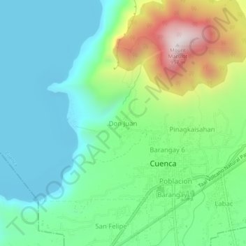
Name: Don Juan topographic map, elevation, terrain.
Location: Don Juan, Cuenca, Batangas, Calabarzon, 4222, Philippines (13.88814 121.02249 13.92814 121.06249)
Average elevation: 264 m
Minimum elevation: -4 m
Maximum elevation: 931 m
Thank you for supporting this site ❤️
Make a donation
Make a donation
Other topographic maps
Click on a map to view its topography, its elevation and its terrain.